Cloudy, some fog, times of rain, drizzle, and just cloudiness, east breeze
Temp profile this afternoon
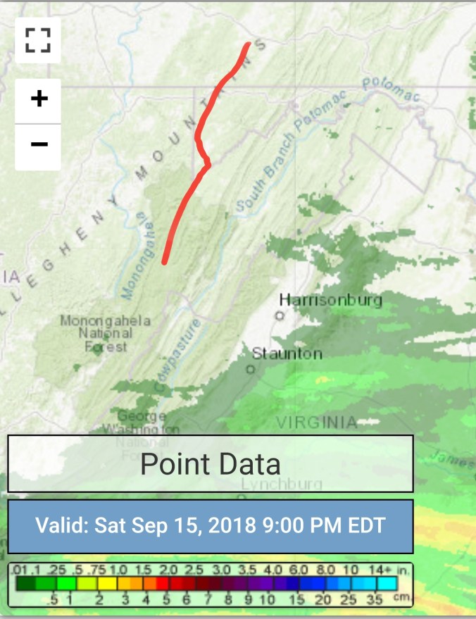
Radar with estimates 9pm-9pm, .23 rain at Bittinger 2nw Valley, .7 at Bald Knob, .5 at CRN at Canaan, .4 at Spruce Knob
Satellite
Flow
Surface features and 500mb height anomalies and flow
On the models…
Rain, cool yet tomorrow into early Tuesday. Milder Tuesday but the rain threat exist into Wednesday. Not constant, but a on and off fashion.
Further out, the chill for the weekend looks weak, and overall the big chill is delayed. Models differ on the outcome. Some ensemble members still carry the 1st flake threat in early Oct..some members keep the stubborn ridge in place directing the chill further north. Models in limbo on that, plenty of time for things to change.
18z 3km Nam 2m temperatures
18z 3km Nam Simulated Radar
12z ECMWF precip type next 240hrs
12z ECMWF 2m Temperatures
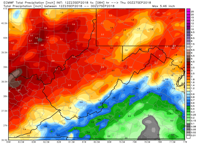
12z ECMWF rainfall through Wednesday
18z GFS precip type next 384hrs
18z GFS precip through Wednesday
The slow go on the foliage. There is some decent fall color on Canaan Mt, and pockets. Really depends on tree type, soil, location to those areas. West side of Cabin Mt mostly green yet. Here is a comparison of 9/22/17, to today 9/23/18
Partly cloudy skies through the heart of the day, with periods of mostly cloudy skies
Temp profile this afternoon
Radar with estimates 9pm-9pm At Bittinger 2nw Valley , picked up .25 past 24 hours
Satellite
Flow
Surface features and 500mb height anomalies and flow
On the models….
Rain pressing in overnight, and south of the mason dixon, a wet Sunday setting up. Temps holding 52-58 for most, 47-53 Wv high ground. Wet weather continues into Tuesday. Overall looking like a 1-3″ rain event. Chilly weather continues through Monday with moderation Tuesday.
Further out, models have delayed and backed off how much “chill” pushes in for early October. The 18z GFS returned to a stronger push Oct 5-8… However it originally appeared next weekend was the onset. That is not to say we won’t see some valley cold before that period. Concerned about the amount of warmth off the mid Atlantic coast feeding back and keeping a stubborn ridge and sw flow aloft , limiting the fronts ability to push through and bring in early season cold. As wave lengths shorten, and cold builds north, that location of warmth can be our friend for inland snows. Way far off and loose speculation.
18z 3km Nam 2m temperatures
18z 3km Nam Simulated Radar
12z ECMWF precip type next 240hrs
12z ECMWF 2m Temperatures
12z ECMWF precip totals through Tuesday
18z GFS precip type next 384hrs
18z GFS 2m temperatures
18z GFS precip totals through Tuesday
18z GEFS ensemble means… 500mb height anomalies and 2m temp. Really just holds the overall pattern through week 1 Oct. The 18z op run was different, more importantly the 12z ensemble mean looked cooler Oct 5-8. Again, models may adjust and pull back as we get closer.. Only time will tell. The “warm” look to the GFS ensembles that are nearly opposite of only a few days ago.
leaves…..
The very poor foliage look continues..Some of the typical more vivid pretty locations with lots of maples are just plain “blah”. Lots of premature leaf drop, and sickly speckled looking dull colors, with healthy looking trees mainly green yet, really poor colors. I do believe this will be the poorest season for maple colors that I can recall. Birch, birch dominates the Blackwater Canyon, Swallow falls state park, some of the cooler high ground river, creek ravines, and mixed with Red Spruce up high…I still believe they are largely unaffected by anthracnose thats plagging some other varieties, namely making that are so vivid usually in the fall.
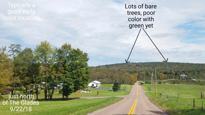
Example of a area that typically very colorful, pretty. South of Bittinger, north of the Glades. Brenneman Hill in Garrett County Md. Lots of bare trees. I’d estimate 40%+. Other trees sickly, dull looking leaves with red oaks mostly green, with some of them affected by anthracnose as well, with brown patches on the leaves. The chamber of commerce would scream “shut up”, but very low hopes of vivid foliage from current views of the area. Word is, many areas through the Alleghenies are seeing similar occurences. Green, or yet dull and or premature leaf loss.
Partly cloudy, breezy. . a very brief(less than a minute) light late day shower
Temp profile this afternoon
Radar with estimates 9pm-9pm
Satellite
Flow
Surface features and 500mb height anomalies and flow
On the models….
Short term, much cooler weekend, showers possible tomorrow. drifting southward and mainly mason dixon south showers Sunday with highest threat Wv mts. Much cooler. Some high Wv ground may hold 46-51…
18z 3km Nam 2m temperatures
18z 3km Nam Simulated Radar
Longer range…Will wait until tomorrow to post the op runs, but some new model data today holds a stronger ridge in the east that deflects the brunt of the biggest potential cold push of the season Sept 30- Oct 6… Interesting seeing the change in the ensembles so much after so much consistency…. Will wait several runs to see if this new scenario holds before posting more.
18z GEFS from yesterday to 18z GEFS today. 500mb height anomalies and 2m temp outlook.
Clear start, valley fog, allowing for some cooler conditions to start. Some clouds popping up throughout the day.
Temp profile this afternoon
Radar estimates from 9pm to 9pm. No radar video with no rain in the area
Satellite
Flow
Surface features and 500mb height anomalies and flow
On the models….
Short term, how far south does the line that potentially has some severe storms tomorrow make it tomorrow evening. Right now it looks to be after nightfall tomorrow that the front nears and it appears the line of storms weaken as well, but still may contain some severe cells. Stay alert on that tomorrow, and will post to facebook. Then that front stalls and will be a focal point of another round of rain this weekend. Question is, how far does the front push and where the steady rain sets up Saturday night, and Sunday. There will also be showers Saturday, mainly Wv mts.
18z 3km nam 2m temperatures
12z ECMWF precip type next 240hrs, with precip amounts next 10 days
12z ECMWF lightning density. The model clearly picking up on a dying of the storms tomorrow
18z GFS precip type next 384hrs with precip next 10. (Keep in mind op runs can change significantly on precip placement several days out)
18z GFS 2m temperatures next 384 hours. Now details will fail, overall outlook should hold. What to expect. As we close September and go into October, expect widespread frost ,freezes.. Especially valley freezes and those frost pockets, looking from this far out, a range with some mins falling into the 18-24° range looks reasonable. 28-33 most locations. Again, this will ne tweaked on numbers, and timing.
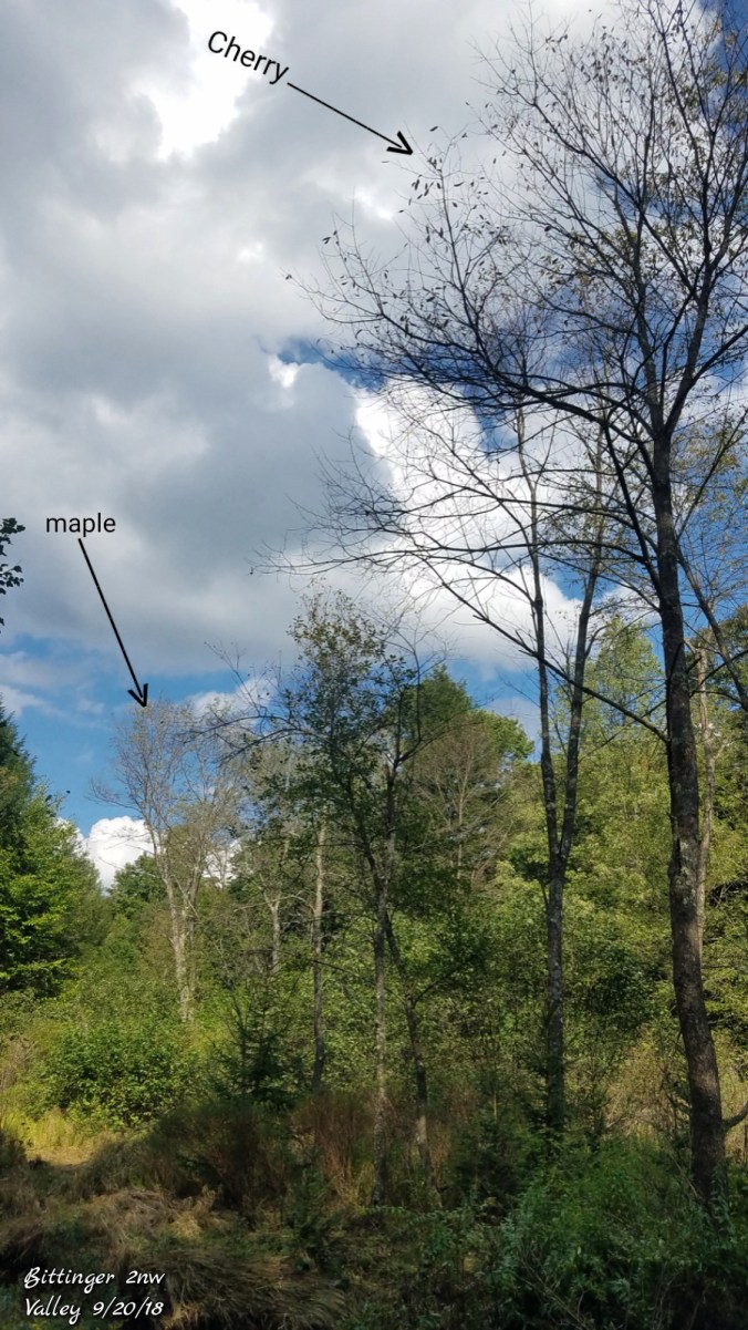
This will kick start areas of slow changing leaves. It may also make for a shortened foliage season. Keep in mind, many areas that have those typical early changers, a lot of those spots, the trees have already lost some leaves prematurely due to anthracnose. You go out on western Cabin Mt across the top. Some maple areas are past peak now, and that did not contain much color, due to early leaf drop. Heres a pick from Bittinger 2nw Valley today
Those leaves fell without much color at all. So, its some of the early changer are bare, others remaining green to just beginning to change. Wv high ground, Sept 29- Oct 6 should be good for best colors. Blackwater Canyon, Oct 4-12… Those cold temps should ignite the change. Many areas will fall in that date range as well. Later than last year with the warmth of this month vs the cold start to Sept last year. Not much off normal, assuming these dates play out this year. Last year, the 2nd half of September warmed, and that slowed down the later changing trees to early Oct.
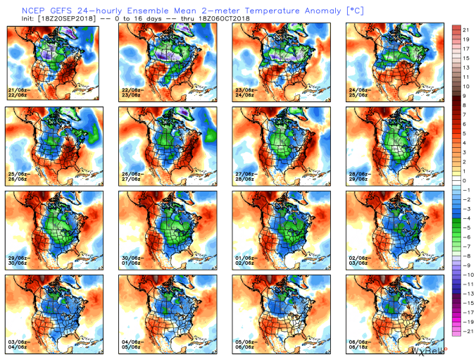
Last but not least. This will all involve timing of the fronts and precip available, first flakes early Oct are not ruled out yet. 3 members of the GFS ensemble package has it, 2 of the ECMWF. Here is the GFS
GFS ensemble temp outlook next 16, frost, freeze opportunity should exist multiple mornings.
Cloudy start, some high ground fog in spots. Breaking late morning and through the afternoon for more sunshine.
Temp profile this afternoon
Radar with estimates 9pm-9pm
Satellite
Flow
Surface features and 500mb height anomalies and flow
On the models….
Warmer 2 days ahead after a cool start in the a.m, cool start relatively speaking vs the mild mornings of this September. On Friday, we do need to watch to see how a line of storm develops. Will post more tomorrow, as of now the worst does look to start in the northern Alleghenies and points NW.
18z 3km Nam 2m temperatures
18z 3km Nam 2m Dewpoints
mid to long term, plenty of rain chances, and then we look to chill down late next week going into early October. Widespread frost and freezes looking probable in that stretch. Last night the 18z GFS had flake threat around the 3rd-4th. Not on any run since. 2 members of the 12z ECMWF ensemble package out of 51 members still have a shot.
A deary rainy start, low clouds, fog. That gave way to breaking skies and some sun during the afternoon.
Temp profile this afternoon
Radar with estimates 9pm-9pm, right at .5 since 6pm last night at Bittinger 2nw Valley
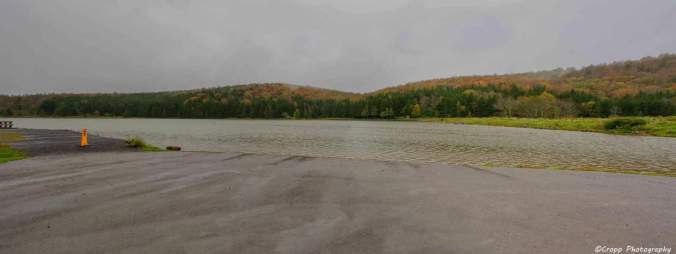
Event rain totals- Bittinger 2nw Valley 1.2, Garrett College 1.3, Grantsville 1.6, Snowshoe 2.0, Canaan State Park .96, Olson Tower 1.3, Blackwater 1.1, Northern Cabin Mt 2.9, Bald Knob 2.2, Spruce Knob 3.1, 7Springs 2.0. Overall 1-3″ event range held well.
Satellite
Flow
Surface features and 500mb height anomalies and flow
On the models…..
Short term, some drier air into the picture.. looking at 10m winds, dew points, some coldest pockets may run in the 39-44 range Thursday morning. Warmer afternoons late this week. 72-80
18z 3km Nam 2m temperatures
18z 3km Nam 2m dewpoints
12z ECMWF precip type next 240hrs, with precip amounts through day 10. Models backed off on the wave along a stalled boundary this weekend. Cooler air as we go into the weekend.
18z GFS…. S, S, S, S YES, the S word is on the model. S should stand for, take with a huge grain of Salt. BUT, its 15 days out, and while October does look to start out cold. I believe first widespread frost and freezes are late Sept or the first week of Oct. The 18z GFS does put out the seasons first flakes around Oct 3rd-4th. At this point, is it likely. NO. Is it impossible, no, its possible. Way too early to tell. How much cold air is able to push on the heels of a early season cold front, and how much moisture is available. Long shots for it to occur. . So the 18z GFS out day 10-16 is as much for fun as to take serious. Having said that, here it is
18z GFS precip type next 384hrs, precip through day 10
Now the flakes on the model…only posting this as its the first run with the cold pushing in and enough so to provide that threat on the season.
Long range as we close out September, open October looks to be on the below normal side of things. Off the 18z GFS ensembles and CFSv2.
Cloudy, rain, moderate to heavy in the a.m…some fog, drizzle, east flow.
Temp profile this afternoon
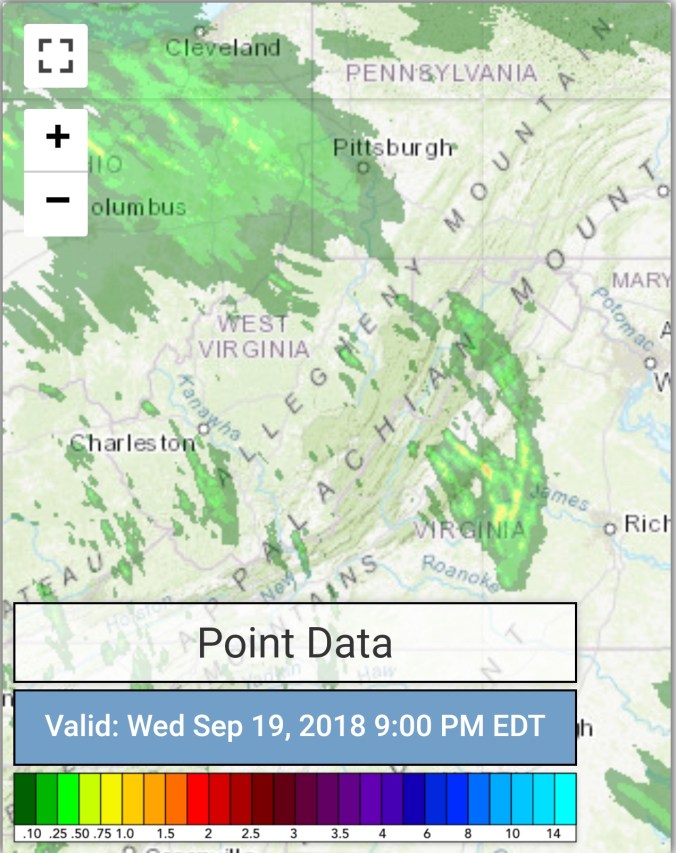
Radar with estimates 9pm-9pm, .65 at Bittinger 2nw Valley
Satellite
Flow
Surface features and 500mb height anomalies and flow
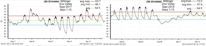
Last years start to September vs this year…
A much warmer front half of September this year, vs last year. Last years foliage season got kicked off rapidly across the high ground with the maples. This year, outside of the early season trees affected with anthracnose, we are lagging last year, but I would not say far off par for normal. The very warm start (front 7 days) to this September has helped the overall average on the month be well above normal, while the daytime maxes the past 8 days have been much cooler, in large part under a east flow, foggy, wet conditions in which may help aid in some color change. One big thing lacking, due to the cloud cover, wet conditions, we have had a blanket to prevent nightime temps from falling off this month. Last year we had some nice big chilly highs push in, clearing us out, letting temps fall. Not the case this year…..and to be honest, I don’t forsee this chance not until the last week of the month or into week 1 October.
At Bittinger 2nw Valley days 1-15 last year to this year.
Max anomalies last year and this year
Min anomalies last year and this year
Overall average anomaly vs norms last year and this year
Precip last year for the month and vs norm
This year month to date and percentage of normal
On the models
Short term, showers tonight, into tomorrow. Coverage becoming less. Overall an additional .25 to .50 possible. Isolated higher amounts.
18z 3km Nam 2m temperatures
18z 3km Nam 2m Dewpoints
18z 3km Nam Simulated Radar
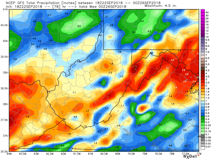
Longer term, upcoming weekend. Watching a stalled boundary with that being the focal point of possibly some more heavy rains. Will it set up in Pa, along the Mason-Dixon, or in Wv. That is a question. The 12z ECMWF was pretty hefty in the area it sets up. GFS not as much. Expect this too wobble north or south on the models over the upcoming week.
12z ECMWF precip type next 240hrs with precip totals through 10 days including tonights rain
18z GFS precip type next 384hrs with amounts through day 10.
Cloudy, some fog early, foggy all day in WV mts, little drizzle early, wetter as you went south in WV mts. I had a few peaks of sun, but majority of the time, just cloudy, east flow.
Temp profile this afternoon
Radar with estimates 9pm-9pm , picked up only trace at Bittinger 2nw Valley..
Satellite
Flow
Surface features and 500mb height anomalies and flow
On the models..
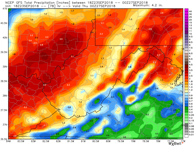
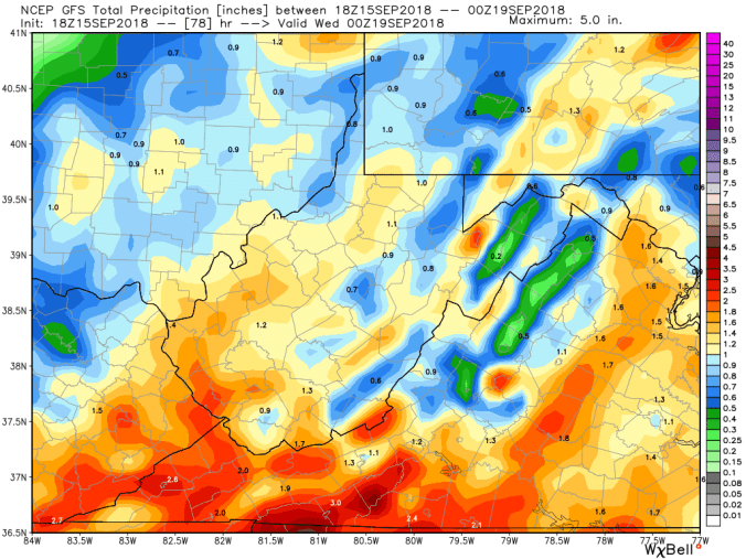
Rain looks to push over the area during the overnight and by dawn tomorrow most all of the area seeing rain. Model output continues in the 1-3″ range, so no need to waver from those totals. Lingering showers through Tuesday.
18z 3km Nam 2m temperatures
18z 3km Nam Simulated Radar and amounts
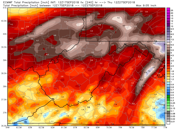
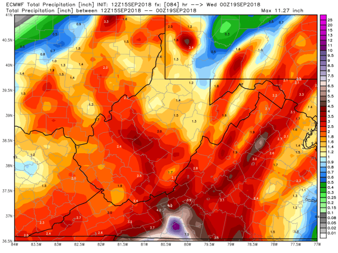
12z ECMWF precip type next 240hrs with amounts through Florence remnants
18z GFS precip type next 384hrs with amounts through Florence remnants
Mainly cloudy, times of fog, drizzly, times of light rain…a few brief peaks of sun late day..
Temp profile this afternoon
Radar with estimates 9pm-9pm, once again, radar not picking up on the light precip banking into the Alleghenies. The mist, drizzle, light rain at times. Only totalling .02 at Bittinger 2nw Valley, but wet quite often today. That said, radar and radar estimates not worth much , but here they are…(radar clutter near radar sites(Pitt, Charleston, Sterling)
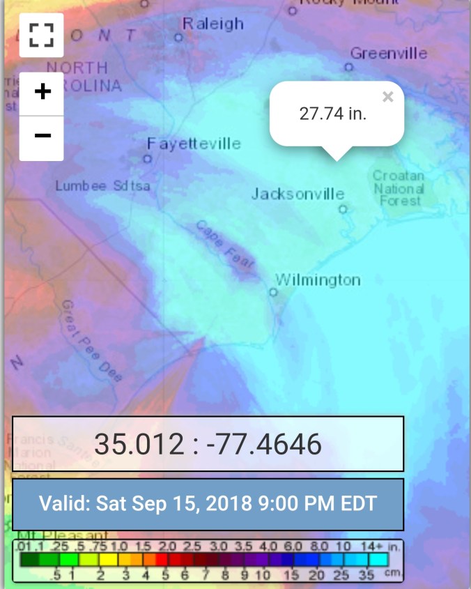
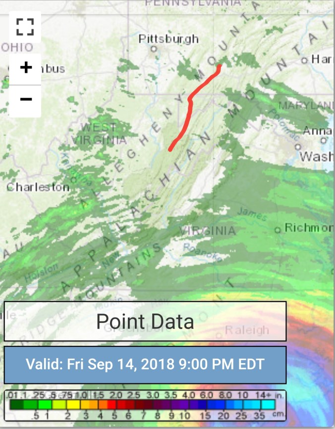
Florence estimates and some obs reports 25-32″..There was a gauge earlier reporting 47″, I inquired about it and was told it was a error impacted by sea spray
Satellite
Flow
Surface features and 500mb height anomalies and flow
On the models
Rain threat increasing Sunday late day south, and overnight pressing north. Rainy Monday, into Tuesday. Overall holding the 1-3″ range, while leaning in the low to mid range of that. As always isolated spots may recieve more.
18z 3km Nam
2m temperatures
18z 3km Nam Simulated Radar
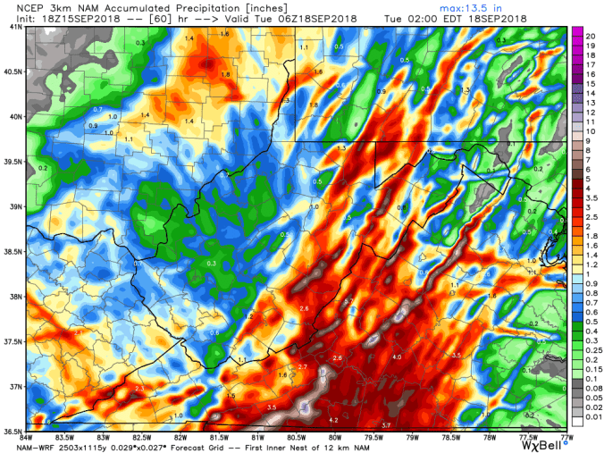
18z 3km Nam precip totals
12z ECMWF precip type next 240hrs, with amounts through Florence remnants
18z GFS precip type next 384hrs, with amounts through Florence remnants
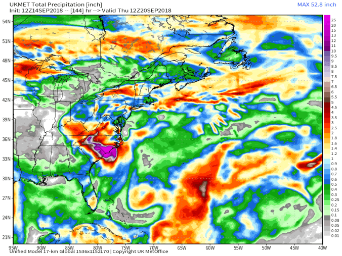
12z UKMET precip every 6 hours with amounts through Florence remnants
Drizzly, foggy, east flow, isolate brief peak of sun, 99% of the day was foggy, misty, drizzly. Temp max was with brief peak of sun. The eastern ridges of the Alleghenies were socked in with pea soup thick fog. Temps held 60s.
Temp profile this afternoon. Large difference in temps and conditions from east side of the Alleghenies to the downsloping valleys on the west.
Savage Mt to Morgantown today off cams
Pic by Steffi Hone on Spruce Knob
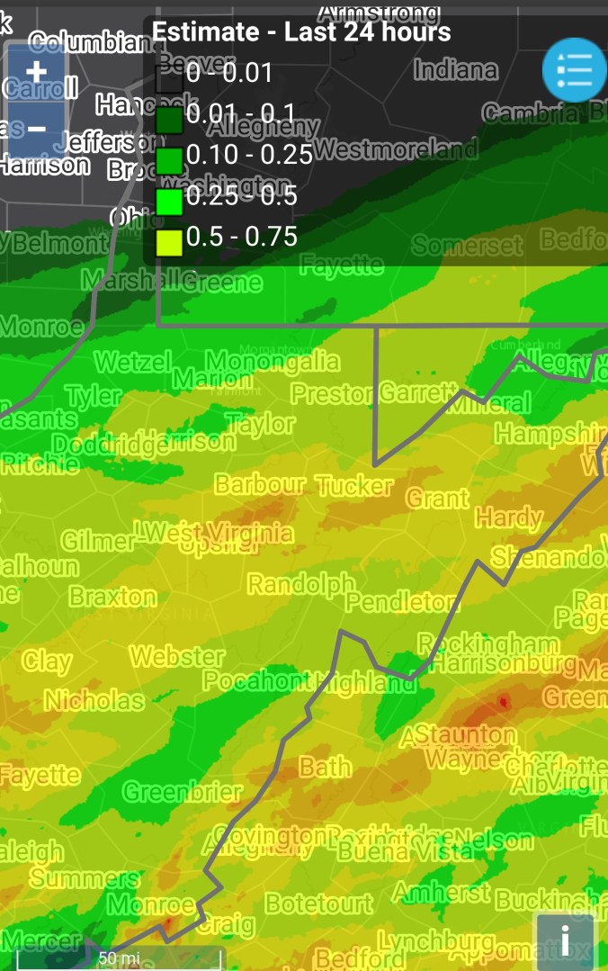
Radar with estimates 9pm-9pm, picked up .05 at Bittinger 2nw Valley… Radar and estimates misleading on this version. Lots of ground clutter near the radar sites. and the low moisture banking up the mts on the east side, noy detected. Leading to errors in radar estimates as well. Not that it rained a lot, but wet most of the day.
Satellite
Flow
Surface features and 500mb height anomalies and flow
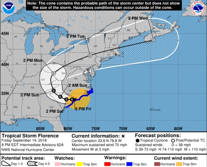
Florence
Florence estimates
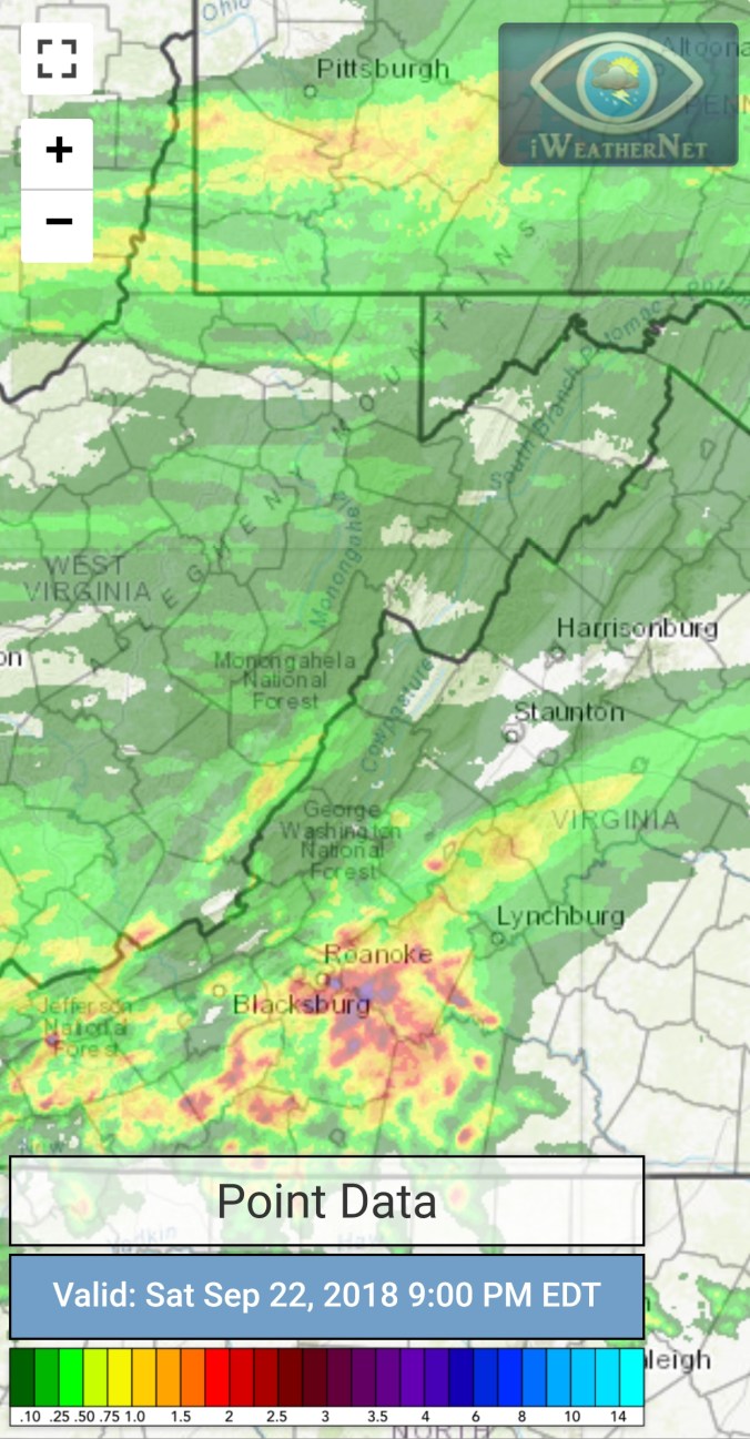
on land, weakening, but moving slow and dropping lots of rain. Our rain looks to begin south to north late Sunday/ Sunday night, through Tuesday..Again, a tweak up in arrival and exit. Showers will occur over the time between now and then, especially the eastern ridges that were socked in the fog and drizzle today. Rain looks to be in the 1-3″ totals, with isolated higher amounts. Really riding the Euro(Ecmwf) on this. The GFS just looks odd. With a brunt of the precip occuring with S/Se winds, it makes 0 sense to dry out the downsloping areas on the east side of the Alleghenies like the GFS does, the ECMWF does the opposite.
12z ECMWF precip type next 240hrs, precip amounts through Florence remnants
The 18z GFS precip type next 384hrs with precip amounts only through Florence remnants
12z UKMET precip every 6 hours through 144 with amounts
Short term, again, not much flucuation in temps across the mts from night time lows to day time highs.
18z 3km nam 2m temperatures
18z 3km Nam Simulated Radar
Leaves……
Nope still here. The leaf season. This is setting up to be a funky fall foliage season. Mentioned in many post in late August if you were following about a fungal disease caused by the wet weather causing some tree types(especially maples) to drop leaves premature. Some leaves shrivle, some spot up, and hang on. Well that seems to have affected a portion, how much, depends on the area. Lots of those fell ,leaving primarily green maples with some color. I was walking around observing this evening, lots are on the verge of change across my area in Garrett County. I think the shorter days, and the cool down in max temps the last week after the very warm September start, and the constant cloud cover may be helping, but not as much if we would get some clear cold nights. They have been few in this overall wet damp pattern.. That said, this year vs last year on this date is very noticeable. Remarkably less color. Last year the maples went early, set off by a cold September opening and early frost. This year, that warm combo, with some early maple leaf loss, has left the early changers gone, and remaining mainly on the green side.
On the verge, I tend to think these will start to change fast despite the lack of cold temps in near term.
Last September start vs this year
32 between Davis and Canaan Heights on Sept 14 2014, vs today


 Satellite


 12z ECMWF lightning density. The model clearly picking up on a dying of the storms tomorrow


 Radar with estimates 9pm-9pm, right at .5 since 6pm last night at Bittinger 2nw Valley
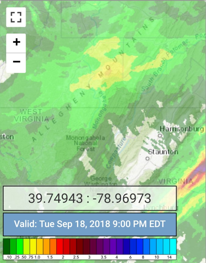


 Radar with estimates 9pm-9pm, .65 at Bittinger 2nw Valley
 Satellite


 Radar with estimates 9pm-9pm , picked up only trace at Bittinger 2nw Valley..
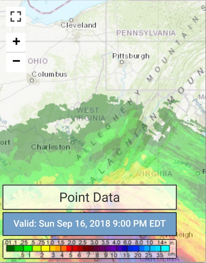 Satellite


 Satellite