June 6                      min.         max.       avg

Bitt 2nw valley      41.7         54.0       47.8

Garrett College     44.2         54.2       49.2

Can-Heights         41.3          56.7      49.0

CRN-Canaan         38.9         57.1      48.0

Cabin Mt                39.9        56.5      48.2

Cabin Mt north no data

Spruce Knob         42.1       58.6       50.3

Snowshoe              45.7       56.5       51.1

Can-Valley Floor

Green Bank no data

7Springs           offline

Cloudy Garrett and north the entire day. I even had a little mist at 2-3pm..Windy and cold. Temps held 40s a large part of the day. Highs occured at midnight, not often is that the case in June. Garrett Airport, not sure they cracked 50 this afternoon.

Temp profile this afternoon2018-06-07-21-22-51

rtma_t2m_conus2-1

Satellite today…showing the cloud cover Garrett and north and sun south.

June 5.                      min.        max.      avg

Bitt 2nw valley       42.8        65.3        54.0

Garrett College        46.7       64.1       55.4

Can-Heights             47.6       61.1       54.3

CRN-Canaan            49.0        59.2      54.1

Cabin Mt                  45.0        58.1      51.5

Cabin Mt north no data

Spruce Knob          44.4         59.0      51.7

Snowshoe               46.4        57.7       52.1

Can-Valley Floor

Green Bank no data

7Springs             52.2          62.7       57.5

Clear to quickly clouding up, showers in the morning..some breaks in clouds afternoon, gusty winds with showers again late evening. Really another day that felt like fall.

Temp profile this afternoonrtma_t2m_conus2

Radar

Satellite

June 4                   min.        max.       avg

Bitt 2nw valley    51.4       64.8        58.1

Garrett College    54.1       65.7       59.9

Can-Heights          50.5      62.9       56.7

CRN-Canaan          53.0     61.8       57.4

Cabin Mt.               49.5      60.4      55.0

Cabin Mt north no data

Spruce Knob         48.6         59.9     54.2

Snowshoe              48.7         59.0     53.8

Can-Valley Floor

Green Bank no data

7Springs               56.3          67.4       61.8

Mainly cloudy in the a.m giving way to partly cloudy skies in the afternoon that continued to thin by evening. Lowering dew points, stiff breeze temps upper 50s, to mid 60s gave a fall like feel.

Temp profile this afternoonrtma_t2m_conus2

June 3.                       min.      max.      avg

Bitt 2nw valley        55.3       65.6      60.4

Garrett College       56.0        67.4      61.7

Can-Heights           59.5        69.5       64.5

CRN-Canaan         59.1          69.7      64.4

Cabin Mt                 57.6        64.6      61.1

Cabin Mt north no data

Spruce Knob           56.1        69.6      62.8

Snowshoe                55.6        68.4      62.0

Can-Valley Floor

Green Bank no data

7Springs              58.0           65.6       61.8

Cloudy, foggy, light rain…much heavier rain just east of the Alleghenies with flooding in the Berkley Springs, Cacapon area.. temps falling into the 50s late afternoon in Garrett.

Temp profile this afternoonrtma_t2m_conus2

Radar

Satellite

Flow

closer look


Pics in that area and estimated 24 hour hour rainfall amounts(48 hour even more impressive)

Blackwater at Davis maxing out around 1800cfs. Thats high but nothing extreme or even abnormal after a good rain event

June 2.                   min.        max.       avg

Bitt 2nw valley       61.5        70.2       65.8

Garrett College      62.7         70.4       66.6

Can-Heights            60.2         64.6      62.4

CRN-Canaan          59.0          65.0      62.0

Cabin Mt                57.9          61.3      59.6

Cabin Mt north no data

Spruce Knob        56.5            59.7    58.1

Snowshoe            57.2            59.0     58.1

Can-Valley Floor

Green Bank no data

7Springs              65.5         74.7        70.1

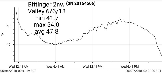
Rain, heavy rain morning Wv mts, Garret saw heaviest period afternoon…totals 1-3″ past 2 days. I have 1.6 through 6pm Bittinger 2nw since yesterday evening

Temp profile this afternoonrtma_t2m_conus2-1

Radar

Satellite


3km nam temps through Monday


*Snowshoe new station site listed at 4800′ begins today

June 1.                   min.         max.       avg

Bitt 2nw valley     59.7         76.3        68.0

Garrett College    63.5         78.9        71.2

Can-Heights          59.8        74.6        67.2

CRN-Canaan         61.2        74.4        67.8

Cabin Mt                57.2        72.7       64.9

Cabin Mt north no data no

Spruce Knob        55.9         71.8       63.9

Snowshoe            57.2          70.5       63.8

Can-Valley Floor

Green Bank no data

7Springs            64.5         75.7       70.1

Early clouds, sprinkle giving way to sunshine through the heart of the day. That then gave way to late day showers.

Temp profile this afternoonrtma_t2m_conus2-1

Radar

Satellite afternoon/evening

May 31.                     min.         max.      avg

Bitt 2nw valley       60.8          74.8       67.8

Garrett College       65.9          77.1      71.5

Can-Heights           62.9           73.2      68.1

CRN-Canaan          62.3           72.1      67.2

Cabin Mt.               60.3           70.7      65.6

Cabin Mt north no data no

Spruce Knob         59.2          70.5      64.8

Snowshoe/S.C       61.3           70.5     65.9

Can-Valley Floor

Green Bank Obs.  no data

7Springs                 67.3         78.4     72.9

On and off rain, intervals with sun. Muggy day

Temp profilertma_t2m_conus2-1.png

Rainfall past 48 hours with brunt past 24 hours. Flooding in skyline drive area
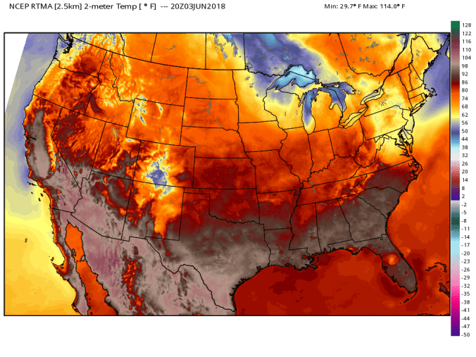
Screenshot_20180531-203631

Radar today

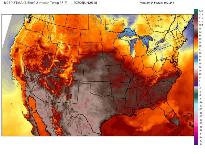
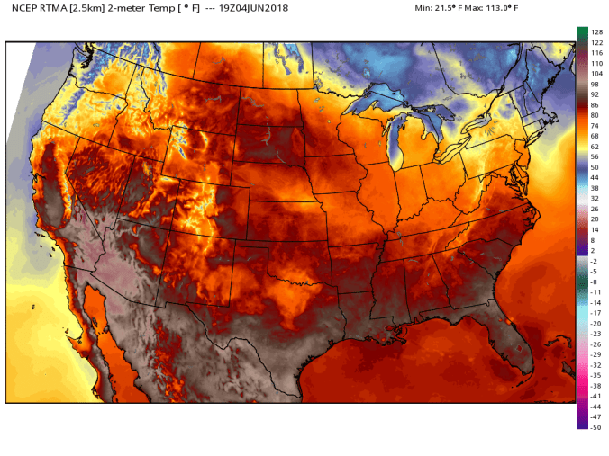
Satellite this afternoon

May Summary

Bittinger 2nw Valley and Canaan data put together by Dave Lesher

Overall a warmer than normal May, and wetter than normal. After a cold April we went into May leafless and that carried into mid month, and some areas to week 3 with minimal foliage. Thoughts on that, that limits evapotranspiration and allows for more daytime heating in an already warm pattern. So, a cold April can IMO contribute to an even warmer May due to that. By no means was that a cause of warmth, the overall pattern flipped to a summerlike one after the cold April. Lots of cloudy nights with the wet held temps up overnights. Overall combo of the above led to a very warm May.

2018-06-02-08-36-04


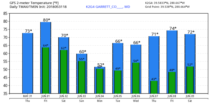
18Z GFS modeled temps next 10 days. Possibility next week as brief high works in, if it times out correctly, the coldest valleys could run a frost risk.K2G4_2018053118_gfs_min_max_10

12Z ECMWF a bit different look on the coming cool. K2G4_2018053112_ecmwf_min_max_10-1

May 30.                  min.         max.        avg

Bitt 2nw valley    61.1          72.6        66.8

Garrett College    64.4          74.0       69.2

Can-Heights         62.1           70.9       66.5

Can-Canaan         62.9           72.0       67.4

Cabin Mt               59.5          66.0       62.8

Cabin Mt north no data

Spruce Knob          58.1         65.1       61.6

Snowshoe/S.C         59.9        66.2       63.0

Can-Valley Floor

Green Bank Obs no data

7Springs                65.1         75.8      70.4

Cloudy, few light periods of passing brief rain….breezy, some fog, little sun at times.

Temp profile


Radar

Satellite

May 29.              min.       max.       avg

Bitt 2nw valley  56.4       80.1       68.2

Garrett College  59.7       81.2       70.4

Can-Heights       58.8        75.1      66.9

CRN-Canaan       57.4       76.1      66.7

Cabin Mt             59.5       73.9       66.7

Cabin Mt north no data

Spruce Knob      57.9       69.1      63.5

Snowshoe/S.C   57.6        71.2       64.4

Can-Valley Floor

Green Bank Obs no data

7Springs              67.3        78.4     72.9

Partly cloudy, isolated few and far between afternoon showers

Temp profile


Radar

Memorial Day

May 28.                   min.        max.      avg

Bitt 2nw valley      62.1         77.6      69.8

Garrett College      64.4        79.9       72.2

Can-Heights           59.9        76.7       68.3

CRN-Canaan          60.3        76.6       68.4

Cabin Mt                59.4        73.9      66.7

Cabin Mt north no data no

Spruce Knob        57.9        69.6     63.8

Snowshoe/S.C.     58.5        72.1     65.3

Can-Valley Floor

Green Bank Obs.  62.0      79.4     70.7

7Springs                 65.1      85.2     75.0

Fog, cloud cover early morning giving way to some partly cloudy skies. Showers developing southern Alleghenies in the afternoon with some flash flood warnings in spots.

Temp profile this afternoonrtma_t2m_conus2-1

Radar

Satellite afternoon 5/28/18