Mainly clear start, valley fog. Clouds developing midday with pockets of heavy rain beginning in the southern Alleghenies, spreading north. Coverage less than yesterday. Rain avoided Garrett County. Near Mt. Davis north a slow moving heavy cell developed in Somerset County. Brief heavy cell near Spruce Knob. Heaviest area looks to have been near Slatyfork off radar estimates.
Temp profile this afternoon
Radar
Radar estimated amounts
Satellite this afternoon
Flow
Dolly Sods, WV,Bearden Knob
Dewpoints off the 3km nam, much more comfortable air set to push in
*Green Bank max likely reading to high everyday. Station listing here will be discontinued
*7Springs site will be changed starting today 7/15(metadata under the about menu option, as with other sites)
*Snowshoe site will begin using the 4711′ site July 16 and present 4800′ site that appears to influenced by site will be discontinued in listing.
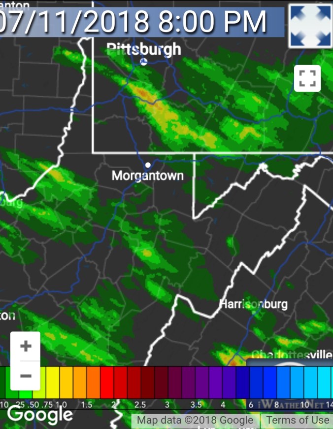
Cloudy to start, then some sun in the a.m hours. Wv mts saw some showers developing. These showers/storms really blossomed early afternoon. Some areas with heavy downpours while some areas saw very little. Rain limited to southern areas by late evening, nightfall
**heard first katydid of the season tonight.
Temp profile this afternoon
Radar
Radar estimates
Station amounts through 8pm
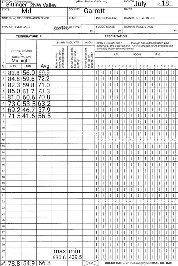
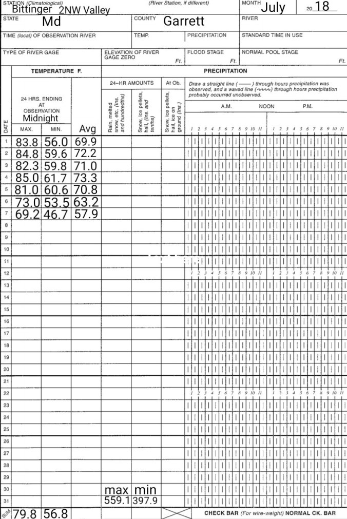
Grantsville .37
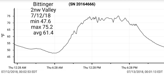
Bittinger 2nw Valley .15
Mchenry .7 (.4 just east at GCC)
Davis .28
Canaan Heights .28
Northern Cabin Mt .16
Bald Knob .25
CRN-Canaan .21
Spruce Knob 2.80
Snowshoe 1.71 finished at 1.8
Monterey .7 finished at .8
Rainfall rates impressive, view towards Spruce Mt at 12:55 from North Fork Mt
Satellite this afternoon
Flow
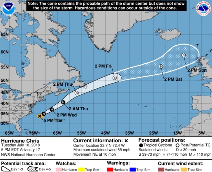
Beryl very unimpressive out in the Atlantic
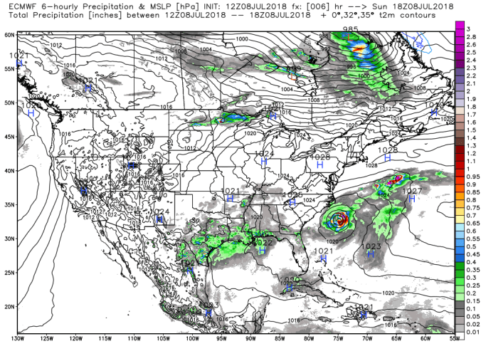
Surface features and 500mb Height anomalies today
Pics by Paula Kay Varndell near Bruceton Mills this afternoon
Pics by Erica Umbel north of Friendsville this afternoon
West of Bittinger afternoon..lighter rains vs nearby areas
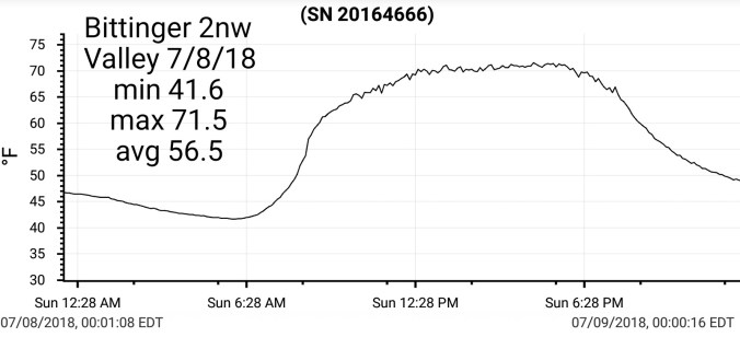
Clear start, lower dew points…calm north, with a breeze kicking in Wv mts. This held up temps there slightly vs Garrett and north. A mix of clouds and sun during the day.
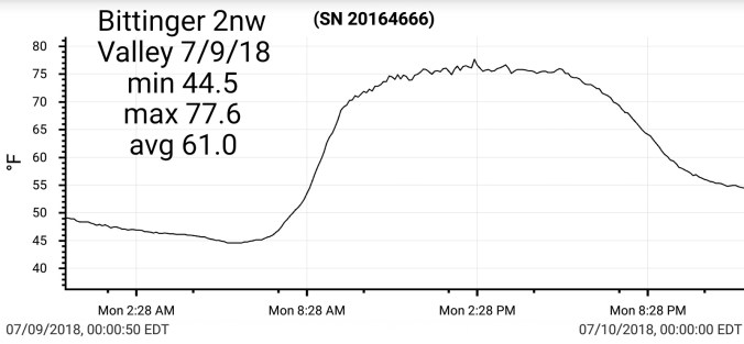
Chilly valley start, clear skies, calm winds. Mainly sunny day, passing clouds at times, dewpoints still in the comfortable range, up slightly vs yesterday.
Temp profile this afternoon
The Glades dropping to 37.6 overnight. A much calmer night with minimal mixing. Models, including 3km nam did poor with indications temps would fall as much, GFS somewhat better. Generally 4-8 under modeled dewpoint if calm winds, clear skies rule in these coldest pockets.
At 6:20am, temp was 39° at The Glades while 59° at Keysers Ridge
** Green Bank appears to have siting issue. Temp affected by solar radiation. Snowshoe site at 4800 may be somewhat as well, 4711 site included for comparison.
Wall to wall sun, comfortable dew points…beautiful day
Temp profile this afternoon + dewpoints
The Glades overnight. Easy to tell there was plenty of air mixing at times overnight. Light SE breezes at times. Temp fell to 41 by 11pm overnight, then a rise to 51 by 1am, back to 43, back to 50 to a calm period before dawn allowing for the temp to fall back to 40. Now, Bittinger 2nw Valley being more protected, did not see the mixing and did not see the rapid falls and rises. It also doesn’t cool as rapidly as the bog in prime conditions.
Satellite this afternoon
Flow
Look at surface features this afternoon
Videos of the Big Savage Tunnel on the Great Allegheny Passage


 Radar
Radar


 Flow
Flow


 The Glades dropping to 37.6 overnight. A much calmer night with minimal mixing. Models, including 3km nam did poor with indications temps would fall as much, GFS somewhat better. Generally 4-8 under modeled dewpoint if calm winds, clear skies rule in these coldest pockets.


 Satellite this afternoon, with blue sky. nl need for zoomed im version
