Cloudy, rainy, some fog, dreary until early afternoon…things began to break..drier air pushing in late day, a change from the mugginess of late
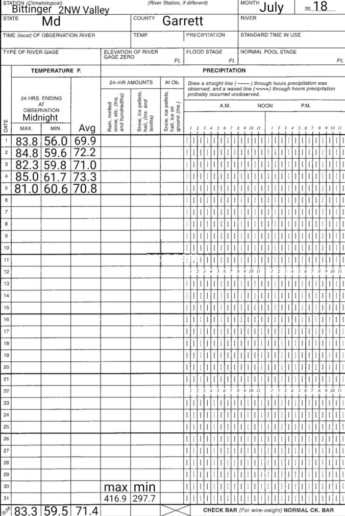
Temp profile this afternoon
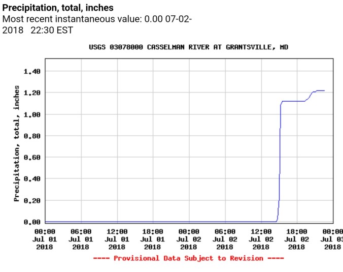
Radar, and Grantsville and Davis gauges. Radar estimated precip, for whatever reason is horribly off today. Most Wv sites, Cabin Mt, Canaan Heights, CRN, Spruce Knob all in between .1 to .3, Garrett College at .4
Satellite this afternoon
Flow
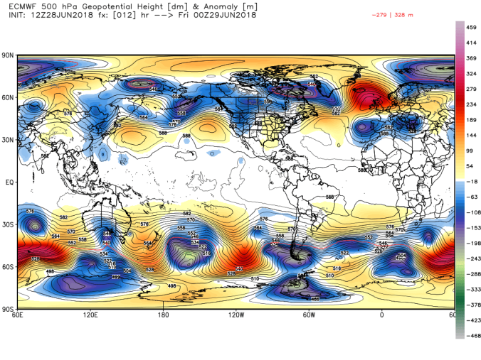
500mb flow
Sunset at Rt 40
3km nam showing drier flow, cooler temps…tomorrow night, if, big if, if things go calm, coldest pockets should run down to or just under dewpoints.
More clous than sun to start, little valley fog. Some areas of morning run, some mostly cloudy with a little sun. Areas in Pa heavy pockets of rain early. This transitioned into more coverage of slow moving pockets of very heavy rain.
Temp profile this afternoon
Radar
Radar estimated amounts
Social media pics, first 2 by Sid Turner
River Gauges in Savage area vicinity
WU station just across border in Pa in Somerset County near Pocahontas in at over 2″
Wv locations through 10pm, Davis .4, Canaan Heights .3, CRN .07, Cabin Mt north 1.4, Baldy 1.7, Spruce Knob 1.1
updated at midnight Baldy 1.89, CRN .28
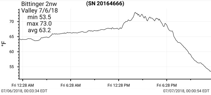
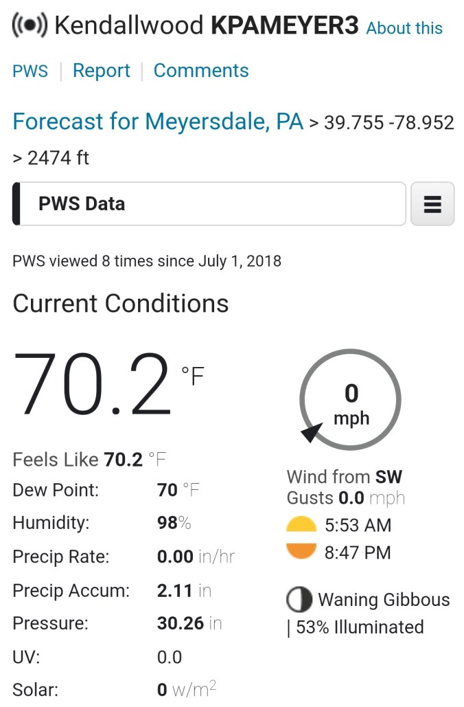
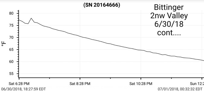
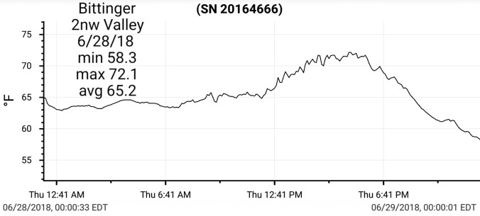
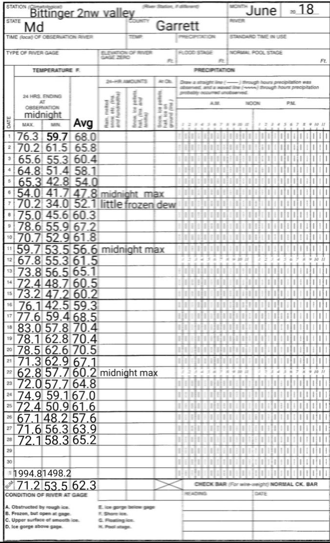
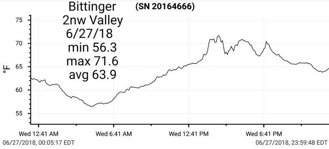
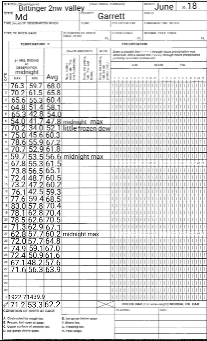
At Bittinger 2nw Valley, under a tenth again as was yesterday.
Mostly sunny to start with some valley fog again. Quickly burning off and temps rising rapidly. At 1pm I recorded my warmest temp of the year. A rise, fall then almost like a brief heat burst a quick rise and then storms broke loose and all afternoon was spent in the 70s. Locations that saw the heaviest rain went into the 60s awhile this afternoon.
Temp profile this afternoon and heat index from 2 different times, and it was a little higher than pictured a few hours earlier. With today being my hottest recorded day year to date, it was short lived.
Radar..and precip estimates. Report of 1.1 near Savage Mt, .4 Grantsville, .9 Cabin Mt at Bald Knob, 1.0 Spruce Knob
Northern Garrett Accident cam not showing up, subbing in Rt 40 near Finzel
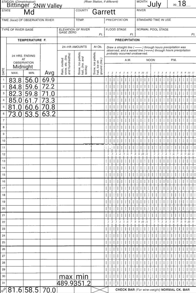
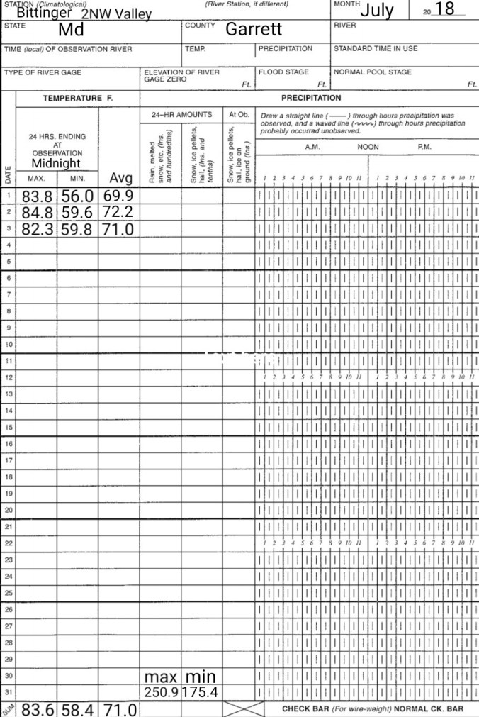
July 3. min. max. avg
Bitt 2nw valley 59.8 82.3 71.0
Garrett College 63.1 85.4 74.2
Can-Heights 61.8 81.5 71.7
CRN-Canaan 59.6 82.1 70.9
Cabin Mt 62.4 78.1 70.2
Cabin Mt north 64.5 80.6 72.5
Spruce Knob 62.4 76.8 69.6
Snowshoe 64.9 82.2 73.6
4711′ 82.2
Can-Valley Floor
Green Bank 65.3 91.4 78.4
7Springs 67.0 87.3 77.3
Clear start, early a.m valley fog, sunshine with building afternoon clouds that led to some pockets of heavy rain, while other areas remained dry. I remained dry at Bittinger 2nw Valley.
Temp profile this afternoon/w heat index off the RTMA
Radar, radar estimates putting out 3″ of rain near Thomas/Davis this afternoon. Given the nature of the slow moving drenchers and the fact Tucker Landfill had 2.3, Davis USGS gauge at 1″, Canaan Heights at 0.0″, 3″ amounts were highly possible.
Satellite
Flow
Lightning pics this evening from just east of Mchenry, overlooking Garrett College and west with the storms near Preston/Garrett line. Also Sunset pic from Rt 40.
Mostly sunny to start, little valley fog. Temps warming rapidly and storms forming midday, early afternoon and running through nightfall. Lots n lots of lightning associated with them.
Temp profile this afternoon
Radar this afternoon + precip estimates that look overdone in areas
Satellite this afternoon
Flow
Few storm reports, mainly consisted of wind, although there were a few flash flooding reports.
Clear, valley fog to start, subshine with a few pop up clouds during the afternoon and evening.
Temp profile this afternoon
Satellite this afternoon
Flow
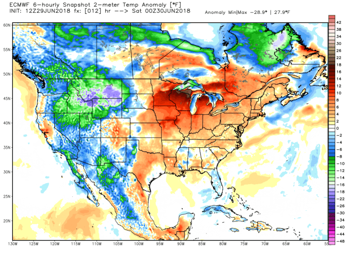
500mb anomaly today
Resulting temp anomaly
With building heights, high pressure, it should still allow for nighttime lows to drop into the comfortable range in the valleys. Warmest nights typically come at the end of the warm spell.
Brief patches of blue at daybreak to light showers, drizzle on and off through early afternoon…then skies began to break
Temp profile this afternoon
Radar(I picked up .25 since 6pm last night) Some areas around Canaan Heights, Davis picked up over 2″ last night. Some areas in western Tucker in lowlands had flooding. Amounts in these areas are greater than depicted by the estimate in the photo.
Satellite this afternoon
Flow
500mb anomaly
Current SST and 7 day change
Upcoming Heat Wave
Earlier in the week, I posted a list of expected temps based off model data. That still looks to hold on par for Sat-Mon, those days being the hottest but holding up beyond that. Here is the list
Johnstown Pa 88-93
Somerset Pa 87-92
Mt. Davis Pa 81-86
Grantsville Md 87-92
Bittinger Md 82-87
Accident Md 88-93
Friendsville Md 89-94
Mchenry Md 85-90
Oakland Md 89-94
Morgantown Wv 93-98
Cumberland Md 97-102
Keyser Wv 95-100
Parsons 91-96
Davis 83-88
Canaan Heights 81-86
Canaan Valley 82-87
Cabin Mt 78-83
Dolly Sods 80-85
Harman 85-90
Seneca Rocks 91-96
Spruce Knob 76-81
Elkins 90-95
Green Bank 88-93
Snowshoe 76-81
Marlinton 88-93
Cranberry Glades 82-87
** Car thermometers, bank/store thermometers will likely read higher than reality during this period. Lots of heat, radation reflecting back off artificial surfaces, objects.
Some numbers off todays 12z Euro Sat-Mon for Snowshoe area, Canaan area, Deep Creek area. Keep in mind, highest locations will run touch under these numbers, lower, town areas will top there numbers.


 Radar, and Grantsville and Davis gauges. Radar estimated precip, for whatever reason is horribly off today. Most Wv sites, Cabin Mt, Canaan Heights, CRN, Spruce Knob all in between .1 to .3, Garrett College at .4

 Satellite this afternoon
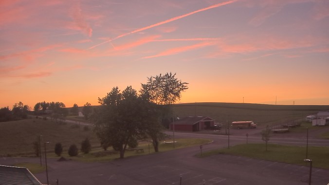


 Radar
Radar


 Radar..and precip estimates. Report of 1.1 near Savage Mt, .4 Grantsville, .9 Cabin Mt at Bald Knob, 1.0 Spruce Knob
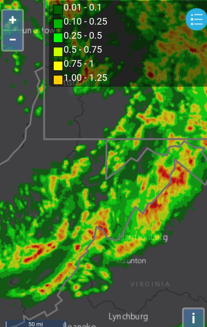


 Radar, radar estimates putting out 3″ of rain near Thomas/Davis this afternoon. Given the nature of the slow moving drenchers and the fact Tucker Landfill had 2.3, Davis USGS gauge at 1″, Canaan Heights at 0.0″, 3″ amounts were highly possible.


 Radar this afternoon + precip estimates that look overdone in areas
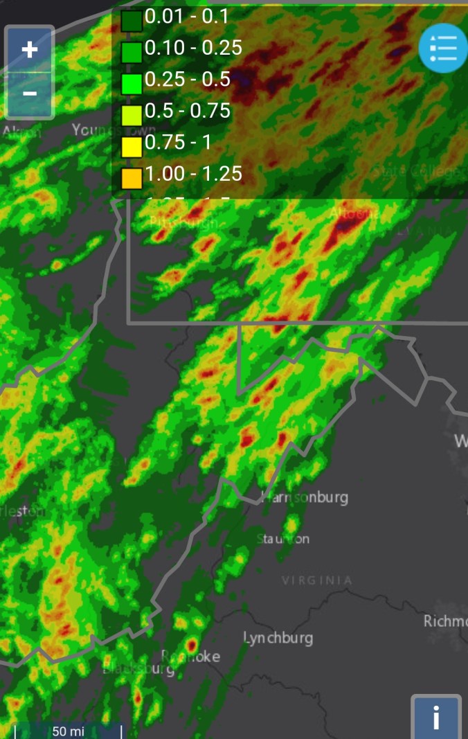
 Satellite this afternoon


 Satellite this afternoon


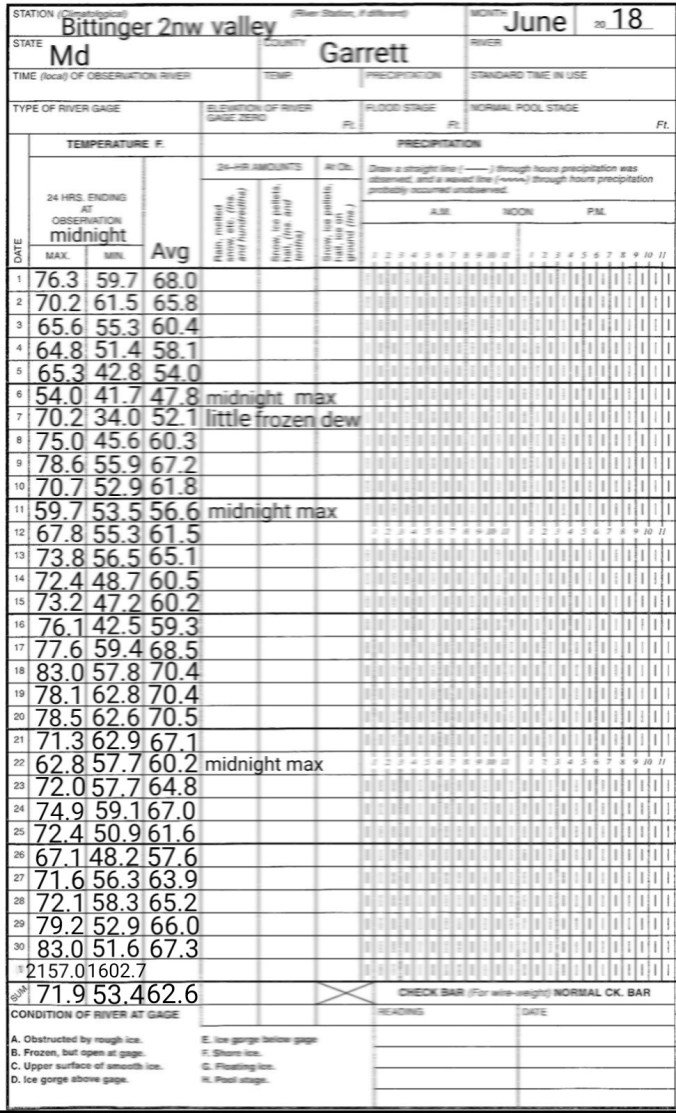
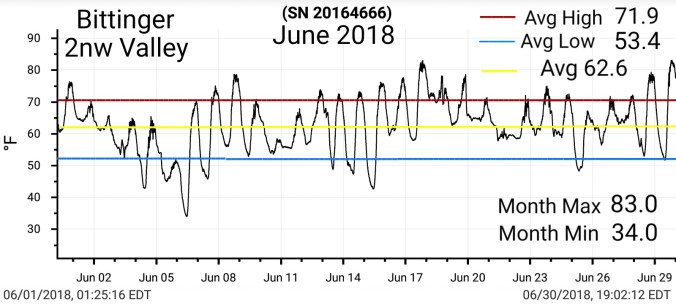
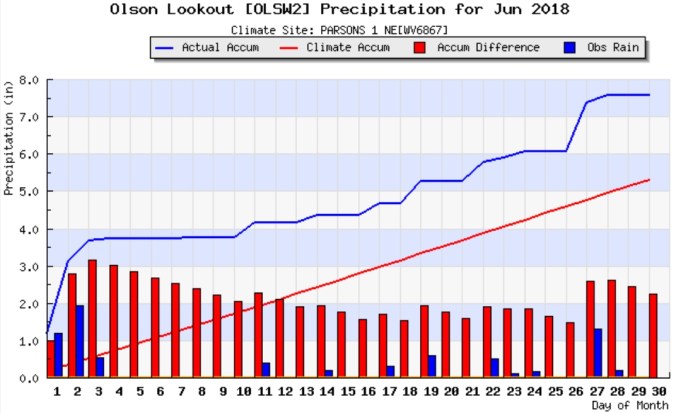
 PRECIP DATA:
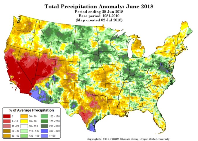


 Satellite this afternoon


 Radar(I picked up .25 since 6pm last night) Some areas around Canaan Heights, Davis picked up over 2″ last night. Some areas in western Tucker in lowlands had flooding. Amounts in these areas are greater than depicted by the estimate in the photo.


 Radar/estimated amounts. I picked up .4 at Bittinger 2nw Valley through 6pm with nearly all of that in the morning hours after dawn.
 Satellite this afternoon